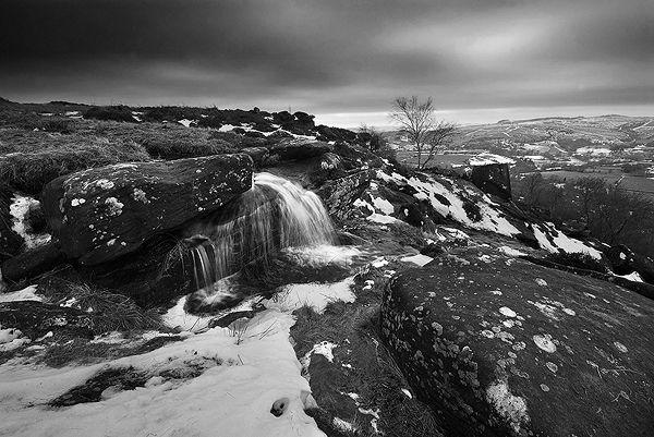
A view of Pule Hill from White Moss on Wessenden Moor
Marsden Moor sits at the very periphery of Yorkshire, in the wild Pennine boarder lands. As the narrowest point of the Pennines, it has been exploited as a crossing point since humans first came to this area. A walk on Marsden Moor is a journey through several thousand years of history.
Since the last ice age, Marsden Moor has been a place of human habitation. Flints from the Mesolithic and Neolithic periods have been found all over Marsden Moor, with particularly important concentrations at March Hill, Windy Hill, Pule Hill and Warcock Hill. These were sites of flint tool production, with numerous cores, flakes and striking hammers found, especially on March Hill, which is amongst one of the most important Mesolithic sites for such finds in the country. More flints were found under the peat at Cupwith Hill and Buckstones. A number of the flint finds on these hills can now been seen in the Tolson Museum in Huddersfield and Saddleworth Museum in Uppermill.

Sunrise view from Buckstones. Pule Hill rises on the left, March Hill on the right.
As agriculture spread across the region and the residents of Marsden Moor became more settled, certain landscape features took on symbolic importance.
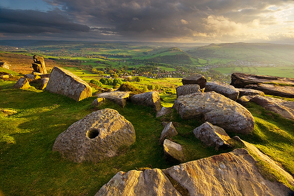
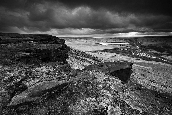
From almost any point of view on Marsden Moor, Pule Hill forms a magnificent centre piece (it can even be seen from Castle Hill, several miles away). It rises, wedge shaped from the moorland floor and affords 360 degree views all around.
The view from Pule Hill, looking towards Warcock Hill, Redbrook Reservoir and Standedge road cutting
The name ‘Pule Hill’ derives from the Celtic and Old English words, peol, pul and pol. Meaning the hill in the marsh. It first appeared as Puil Hill on Greenwood’s 1771 map, and was variously referred to as both Pole and Pule Hill by locals. (1)
It is not surprising that at the summit of this conspicuous landmark, Bronze Age burials and cremations were discovered in 1896 by George Marsden. The cremations were contained within pottery urns, which can now be seen in the Tolson Museum in Huddersfield. James A. Petch decribed the find in a museum pamphlet:
“Several Bronze Age interments have been found in the locality. Of these the most important is that discovered on the summit of Pule Hill and excavated in 1896 by the late Mr. George Marsden. The finding of an arrowhead led to digging and four urns containing burnt human remains, and so-called “incense cup” were uncovered and removed. In 1899 the site was again opened up for further examination. It was then noted that the urns had been set in cavities dug into the rock to a depth of about 18 inches. The type of the urn fixes the interment as belonging to the Bronze Age, and characteristic of such interments are the rock-cavities. The site is however somewhat exceptional in that no trace was found of the mound which was usually heaped over an interment. As the site is very exposed, the mound may have been weathered away, leaving no traces visible to-day. Along with the urns were found an arrowhead, one or two scrapers, a disc, a few pygmies and a number of flakes and chippings. It is important to note that these flints are mostly the relics of a Mas d’Azil Tardenois workshop which existed long before the interment was made on the summit of Pule Hill, and that they have no necessary connection with the Bronze Age burial. (2)

The summit of West Nab
Wherever you are on Marsden Moor, the landscape is dominated by the mysterious West Nab (although strictly speaking, located on Meltham Moor). One feels that this hill is steeped in history and tradition, yet when compared to other local hilltops, such as Castle Hill, surprisingly little is known about it. Rumoured to have been a place of ‘Druidic’ worship, West Nab does not easily give up its secrets (more on West Nab here).
Topped by what I strongly suspect to be a Bronze Age cairn, the mid-winter sun rises over its peak, when viewed from Buckstones. Below the Nab are two earthworks, one being a possible animal stockade dating from the Iron Age. The other being Romano-British and the possible remnant of a temporary camp, from an early Roman attempt to cross the Pennines via Wessenden Head to Greenfield (another, similar fort can be found at Kirklees Park, at the southern end of Calder Valley).

Midwinter sunrise over West Nab, from Buckstones
Roman activity around Marsden Moor was not limited to this one attempted crossing. The Chester to York road passed over Marsden Moor via the fort at Castleshaw (Rigodunum), over Standedge, down Thieves Clough and around the base of Pule Hill, with a possible signalling station at Worlow (3). The road would then have carried on towards present day Marsden and most likely have crossed the river Colne somewhere nearby, before starting the climb towards a second Roman fort at Slack (Cambodunum). The road then struck out towards York, via Lindley Moor.
The Roman history of Marsden Moor is one of pioneers. Yorkshire was not occupied by the Romans until 72AD, when Cartimandua, the Queen of the Brigantines requested their assistance during civil war with her husband Venutius (find more here). The first period of the fort at Castleshaw dates from 79AD, as does the fort at Slack. Both forts being first constructed of turf and timber. It has been speculated that Rigodunum (fort of the king) may have been built of the site of an earlier Brigantine settlement. No evidence to support this however, has yet been uncovered, but Bronze Age pottery has been found at the site (4).
The Flavian period fort at Castleshaws was established by Agricola, covering an area of about 2.5 acres. Protected by ditches and banks, on top of which stood wooden palisades, towers at each corner, plus four gated entrances. The interior contained a number of buildings, including barracks, stables, granaries, workshops, the headquarters and a commandant’s house. There was also a Vicus (civilian settlement) next to the road that ran alongside the fort. The fort was decommissioned around 90AD.
Around circa 105AD, the second, smaller Trajanic fortlet was built on the same site, but using just the southern section of the older fort. On this occasion, the ramparts were built using stone foundations with two gated entrances, enclosing buildings including a hypocaust. It seems that the fortlet was abandoned around 120AD. The fort at Slack was abandoned around 125AD, possibly as a result of diverting forces to Hadrian’s Wall (5). Models of both periods of the fort can be seen at the wonderful Saddleworth Museum in Uppermill.

Overlooking Castleshaws from Northern Rotcher on Millstone Edge, Standedge
Following the Roman withdrawal, Britiain divided into independent kingdoms, quite possibly along similar tribal lines that existed before the coming of the Empire. Although the boarders have never been clearly defined, it is possible that Marsden Moor fell within the kingdom of Elmet (more on this here).
Occupation around the area of Marsden seems to have been sparse during the Dark Ages, with a few piecemeal farmsteads and clearances dotted along the hillsides. A pattern that probably endured up to the Industrial Revolution. Meltham is of Saxon origin and Slaithwaite is probably a Danish settlement, although the area of Marsden may have been inhabited by Norse settlers from Cumbria. Early documents refer to March-dene, which was taken as part of the Honour of Pontefract by Ilbert de Laci, following the Norman Conquest. In 1273, during the reign of Edward I, a thief was apprehended by Hugo, Constable of Almondbury, Henry Odeli and Robert of Marchdene (6). In the time of Edward III (1327-77), the lands around Marsden were part of the Lord’s hunting estate:
The portion of the demesne of Marsden, indeed, is, in an Inquisition of the reign of Edward III, expressly described as a forest two and a half miles long and two broad, and used by the lord as a hunting ground, it being one of the conditions on which the villeins held their holdings that they should escort the lord from Marsden to his chief castle at Pontefract, either personally or with one horse and man (7).
The uninhabited hinterlands of these hills would probably have been the abode of outlaws and highway men. Indeed, the Buckstones Inn had just such a reputation. There is a popular local tale of a ghostly sighting of Highway Men on the A640 New Hey Road near Buckstones, just past Nont Sarah’s pub by a police officer on night duty, dating from 1968.
Elizabeth I sold the manor of Marsden to one Edward Jones, for £29. Later, the manor passed to the Greenwoods, and by the 18th Century, it was owned by the Radcliffe family (the same Radcliffe family who would later pursue the Luddites) (8). The population would soon increase dramatically as the Industrial Revolution came to Colne Valley.
(1) Northern Antiquarian – Dyson 1944.
(2) Early Man in the District of Huddersfield – Petch 1924
(3) Huddersfield & District Archaeology Society – Newsletter Winter 2006/07
(4) northernarchaeologicalassociates.co.uk
(5) Huddersfield in Roman Times – Richardson 1925
(6) Marsden Through the Ages – E. Irene Pearson 1984
(7) The History of the Colne Valley – DFE Sykes 1906
(8) marsdenhistory.co.uk